Service & Area
Quick Links
Sirikuli ,Tajik & Kirghiz
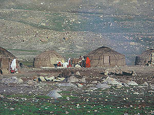
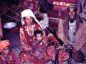
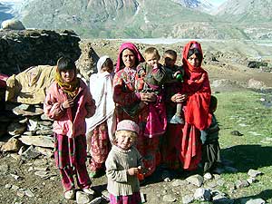
 The Sirikuli people are Turks in origin and different to the Tajiks. Modern historians and Chinese ethonographers have though termed all the minority races and tribes in this region under the single term of “Tajik” and thus they are termed. “ Sari Kol”, “ Zorkol” is a famous lake in the Big Pamir at an elevatioin of 4070mm. Hindukush Trails reconniance into the area have been carried out since 1997. This is a vast area in the Big Pamir close to the Tajik border . Above the lake at Kol Julgah there are two poles marking the boundry between Afghanistan and Tajikastan and dividing the lake too. Between these poles starts a stream joined later by many more streams becoming the Amu Darya or the sources of the Oxus. The sarikul or Victoria Lake is quite long taking us aprox about 3 hrs to walk one side of it. The Sirikuli chief whose guests our reconniances team were, termed the tribe as “ Sirikuli” and they apply the same name to their language. The Sirikuli language is a distinctive dialect of old Persian called Chalcha.The people are also conservant in Wakhi and Khowar.. The Sarikuli live in Yurts and lead a nomadic life with little involvement in state activities. The Sarikuli raise Yak, fat tailed sheep and camel. The two humped bactarian camel is still found amongst their herds.
 At different times the Sirikuli tribe has tried to migrate on the southern side of the Hindukush. In 1936 some of them migrated to Hunza seeking help from the Mir of Hunza but were sent back to the Pamirs. In 1938 some families migrated to Boroghil where the then ruler of Chitral H.H. Nasir ul Mulk gave them land at Lashkargaz. Mirza Rafi who was the last chief of the tribe did much for his comminuty, his family is now prominent in this area.
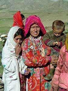
The Tajik live in the scattered oases and side valleys of the Oxus Amu Daria, like their neighbours, they are a mixture of Caucasoid and Mongoloid. The Kirghiz nomads of the Pamirs inhabit numerous valleys of Wakhan. They are a Mongoliod people who originally came from Siberia migrating into the Pamirs in the 19th century remaining there, completely cut of from the world. The general impression of Wakhan /Pamir is “flat high plateau” this isn’t exactly so.
 Hindukush Trails while on reconniance on successive years into both little Pamir and Big Pamir has found that numerous passes need to be crossed. These passes at elevations of 4000 to 5000m interconnect different valleys i.e, Au Baleez pass 4490m,Ghirimdi pass 4680m, Karabel pass 4630m, Warum pass 4600m, Sarhad Chup Darra 4650m where we sited Marco Polo sheep, Kuk Turukh pass 4040m leading into China. Dahleez pass 4070m. Wakjir pass 4600m. All these passes and a few more had to be crossed to traverse the area.
There are numerous rivers and stream crossings that we encountered in our reconniuances some of them were high and difficult to cross while at other points suitable points had to be located for crossings . There were many smaller lakes and the prominent ones that we camped on were Chakmatin Lake 3930m, Sari kul Victoria Lake 4070m, and Lake Dufferin.
 Summer settlements consisting mostly of Yurts were at different heights. Both in 1998 and in successive years we noted these yurt settlements were pitched at the same points. At the lowest elevation at Gaz Khun 3010m which is the meeting point of the Oxus river and Ab I Wakhan and Sarhad 3280m the structures were of stone and mud . While as we moved deepers into Little Pamir and Big Pamir the settlements at much higher altitudes consisted ofYurts and mud huts, like Ochi Jirgah 3930m near Chakmaktin lake, Irgaeel 4000m on the other side, Karah Jirgah 4060m here we were entertained by a Buzkashi, Saeh Tuk 4030m, Birgitiah 4000m, Taulu Tuk settlement 4500m, Sarhad 3280m, Bozai Gumbaz 3770m, Dul Dul 3920m, Turk I Akhun 4440m. beside many others.
The people of the Pamirs are nomadic Kirghiz; squat, gnarled men, and uncomplaining, flat-faced women who because of the harshness of their environment, suffer the highest incidence of still-born babies in the world.
